


We always hear about unstable air rises and form thunderstorms, stable air forms stratiform clouds. So what does it actually mean for a parcel of air to be stable or unstable? Is there such a thing as neutral stability?
To answer these questions we have to learn about lapse rates and the different types of lapse rates. There are three main types of lapse rates:
Environmental Lapse Rate (ELR)
Saturated Adiabatic Lapse Rate (SALR)
Dry Adiabatic Lapse Rate (DALR)
Environmental Lapse Rate (ELR)
This is basically the actual rate at which the atmosphere changes in temperature with height. Now the ELR can be positive or negative and changes with many different factors. For the ISA ELR it is approximately 2 degrees Celsius per 1000 feet. The larger the ELR it is said to be a steep lapse rate, the smaller the ELR it is more shallower. If the ELR is 0 then there is no change in temperature of the air with height, and we call this an isothermal layer. If the ELR is negative then the air rises in temperature with height which gives us inversions.
Dry Adiabatic Lapse Rate (DALR)
If a parcel of air is dry or unsaturated, it will rise and cool down due to the concept of adiabatic cooling. the lapse rate at this occurs is called the DALR and it is fixed at 3 degrees Celsius per 1000ft no matter where you are in the world and whatever conditions.
Saturated Adiabatic Lapse Rate (SALR)
Once air has been completely saturated it will condense and form clouds. Condensation will release latent heat, thus warming the surrounding air which is the reason why the SALR is less than the DALR. At ISA conditions, the SALR is said to be 1.5 degrees Celsius per 1000ft. However, the value of SALR can change and is not fixed depending on the amount of latent heat being released by the parcel of air. Lesser latent heat released, the SALR will be higher but will always be less than the DALR. Vice versa, more latent heat released the lower the SALR.
Determining Stability of the Air
Now how stable a parcel of air is dependent on the temperature of its surrounding air. If a rising parcel of air is warmer than the surrounding air, then the air is said to be unstable. Vice versa, if it is cooler than the surrounding air it is said to be stable. Of course, if the parcel of air is equal to the temperature of the surrounding air we can say it has neutral stabiltiy.
When a parcel of air is colder than its surrounding air, it is denser and therefore will want to sink and this situation occurs when the ELR is less than DALR and SALR. Therefore we could say that if ELR<SALR<DALR, then the parcel of air is stable.

When a parcel of air is warmer than its surrounding air, it will continue to rise and this situation occurs when the ELR is more than the DALR and SALR. Therefore we could say that if SALR>DALR>ELR, then the parcel of air is unstable.

If the ELR is between the DALR and SALR, we call this situation "contionally instability". This means that the parcel of air is stable when it is dry, but unstable when it is saturated.
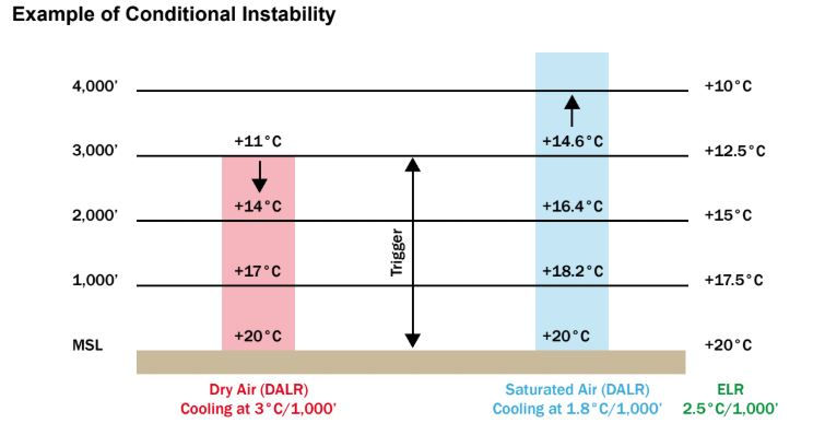
REMEMBER!! THE ELR IS THE TEMPERATURE AT WHICH THE ATMOSPHERE (SURROUNDING AIR) CHANGES WITH HEIGHT NOT THE RISING PARCEL OF AIR. A RISING PARCEL OF AIR WILL ALWAYS COOL AT THE DALR AND WILL ONLY COOL AT THE SALR ONCE CONDENSATION OCCURS.
Leave some comments and please dont hesitate to ask a question below if you dont understand 😆